
Welcome to the Blendworth Hills, Horndean Travel Plan webpage. This page is intended to help you make the most informed travel choices in and around the area that you have recently moved to – be that travelling to the shops, facilities or accessing public transport.

This page is designed especially for you, the residents and staff at Blendworth Hills, Horndean. It will contain up to date information on travel options and your local area, including:
- Local Area
- Walking
- Cycling
- Bus
- Rail
- Car Travel
This information is correct as of March 2026.
Local Area
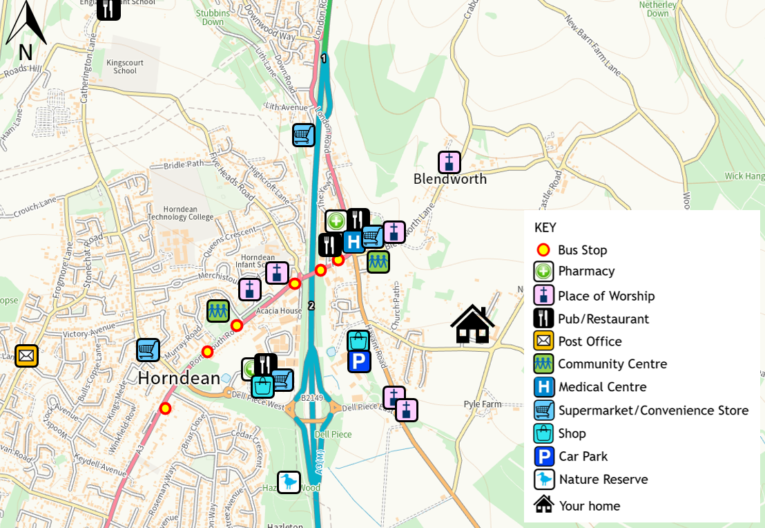
The centre of Horndean is approximately a 15-minute walk away, with a number of local facilities available (as summarised in the accessibility map below). This includes Keydell Nurseries, a pharmacy and a couple of restaurants and cafes. Further afield Waterlooville offers more town centre amenities and can be reached via the 8 The Star and 37 bus services.
These locations can all be reached on foot, by using the new footway that runs from Blendworth Hills access, along the northern side of Rowlands Castle Road, before crossing to the footway on the southern side, when the houses start.
Walking
Benefits of Walking
- It’s free
- Increases cardiovascular fitness
- Reduces anxiety and stress
- Boosts energy and improves mood
- Strengthens bones, improving balance and boosting muscle power
In addition to the new footway connecting Blendworth Hills to Horndean, there are also a number of local walking/cycling routes and Public Rights of Way you may want to explore. You can also utilise Bridleway 119/25/1 to cycle towards Havant.
The map below shows nearby Public Rights of Way to Blendworth Hills but to find other local routes visit: https://maps.hants.gov.uk/rightsofwaydefinitivemap/ to view their interactive map.

Horndean Green Trail & Heritage Network
Whilst still in the development stage, the plan is to have a local trail that will link Horndean, Catherington and Blendworth in a loop. The route will include countryside, sites of natural and heritage interest and local businesses.
When we have more information about it’s implementation we will let you know.
Cycling
A secure and covered mobility scooter and cycle storage area is provided near the village centre, to allow a safe and secure location for bicycles and mobility scooters. Three cycle stands with room for 6 bicycles are also provided in the village centre. To get specific details on their location please speak to the on-site team.
Benefits of Cycling
- Saves money
- An easy way to build physical activity into your daily routine
- Improves mental health
- Cycling plays a huge part in tackling air pollution
- Fresh air, freedom and fun
Local Cycle Routes
National Cycle Network Route 222 runs in the vicinity of the site through Horndean, connecting cyclists to Portsmouth to the south and Farnham to the north.
For more information on cycling in Horndean you can visit: http://www.horndeanpc-hants.gov.uk/Maps__and__Cycle_Routes_4189.aspx
Bus
Local Bus Services
The nearest bus stops to Blendworth Hills are the ‘Precinct’ bus stops located on the A3 near the Premier Inn. These stops are a 15-minute walk away and are served by The Star 8 and No. 37 Services.
The 8 bus service (First Bus) from the ‘Precinct’ bus stops goes to the Queen Alexandra Hospital and Gunwharf; with a service every 15 minutes Monday – Saturday and every 30 minutes on Sundays. Alternatively, the No. 37 (Stagecoach) services travels between Petersfield and Havant approximately every hour.
Timetable information for the No. 8 First Bus service: https://www.firstbus.co.uk/portsmouth-fareham-gosport/plan-journey/timetables/#/timetable/FHAM:8?direction=inbound
Timetable information for the No. 37 Stagecoach service: https://tiscon-maps-stagecoachbus.s3.amazonaws.com/Timetables/South/Portsmouth/Portsmouth%2037_310825.pdf
Alternatively download the bus company Apps to get timetable and real time bus location information to your phone.

Inspired Villages Private Transport Service

Inspired Villages offer a private transport service, known as the Village Transport Services to residents and staff.
The service is available for social outings, shopping trips and hospital appointments. To book the service use the Cubigo App.
Details of the offers for staff are available on request from the Site Manager.
Rail
Rowlands Castle Railway Station is the closest to Blendworth Hills and is 3.8km south-east. The station is operated by South Western Railway with regular services operating between Portsmouth and London Waterloo.
Alternatively, both Peterfield and Havant stations have some step free access, toilets, waiting rooms and refreshment facilities. From Havant Station passengers can also travel across the south coast, mainly between Southampton and Brighton but there are also services to Bristol and London Gatwick or London Victoria.
Car Travel
Liftshare
Liftshare is a free car share scheme where passengers can request a ride and drivers announce their journeys which in turn other users can join. Liftshare is a great way to get around your local area or beyond and make new friends! Request a ride or advertise your journey for free here https://liftshare.com/uk.

Fuel Saving Driving Tips
1. Keep your car in good working order (including your tyres) to help it run efficiently.
2. Drive in the correct gear: ‘high gear for low revs’ meaning less fuel consumed.
3. Brake and accelerate less as this, helps boost fuel efficiency.
4. Plan your trip: Getting lost wastes fuel.
5. Most importantly, try and walk, cycle and take public transportation!
My Journey Car Share
Visit https://myjourneyhampshire.com/ to plan your journeys. The website has advice on travel in Hampshire, from walking and cycling to the latest ticket offers on bus and rail.

Electric Vehicles
Electric vehicles are a great alternative to the traditional petrol or diesel vehicles. Blendworth Hills has 13 electric charging points on site. Speak to a member of staff if you’d like further details on how to use these charge points.
For off-site charge points visit zap-map.com. The website includes locations and charging capabilities of public charging points, nationally. Alternatively, download the Zapmap App if you are on the go.
